


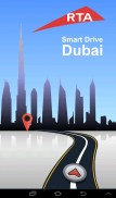


คำอธิบายของ RTA Smart Drive
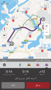
RTA Smart Drive is an on-board route planning, exploration and navigation app that does not require a mobile internet connection to search and navigate.
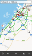
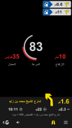
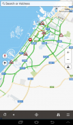
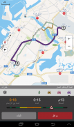
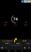
It provides turn-by-turn voice and visual instructions, automatic rerouting, speed limit alerts, and displays POIs along the route.
Live Traffic lets you know where there is traffic, road works and accidents and reroutes your trip automatically. Instantly view real time traffic info and adjusted travel times on multiple saved routes.
Salient Features:
- 2D/3D mode allows realistic view of the map
- 7 levels of POI display
- 3D Landmarks in UAE
- Selection for Automatic, Day or Night modes that switch color schemes for day or night time driving
- Locations of Metro, Tram, Bus and Marine Stations for Dubai
- Parking zones for Dubai
- Regular Map Updates
- User interface in Arabic and English
- Voice navigation in Arabic and English
- Intuitive search across the local Library of POIs
- Search nearby places on Facebook and Foursquare
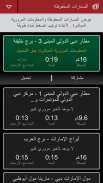
- Live traffic information including road works and accidents
- Report traffic incidents
- Store your personal routes and places locally
- Share your favorite places and routes with your family and friends via sms, email, face book and WhatsApp
- Planning a route – app suggests upto three drive routes and a pedestrian route if possible
- Avoid Tolling and unpaved road
- Simulate your drive
- Speed Limit alerts while driving
- POI along the route
Note: Continued use of any GPS application running in the background can significantly decrease battery life. We strongly suggest using a charger while using the app in your car.
RTA สมาร์ทไดรฟ์บนกระดานการวางแผนเส้นทางการสำรวจและ app นำทางที่ไม่ต้องเชื่อมต่ออินเทอร์เน็ตบนมือถือในการค้นหาและนำทาง
จะให้เปิดโดยหันเสียงและภาพคำแนะนำเปลี่ยนเส้นทางโดยอัตโนมัติแจ้งเตือนการ จำกัด ความเร็วและแสดงจุดที่น่าสนใจตามเส้นทาง
การจราจรสดช่วยให้คุณทราบว่ามีการจราจรงานถนนและการเกิดอุบัติเหตุและการกำหนดเส้นทางการเดินทางของคุณโดยอัตโนมัติ ได้ทันทีดูข้อมูลการจราจรเวลาจริงและการเดินทางครั้งที่ปรับบนเส้นทางบันทึกไว้หลาย
ลักษณะเด่น:
- โหมด 2D / 3D ช่วยให้มุมมองที่เป็นจริงของแผนที่
- 7 ระดับของการแสดงจุดที่น่าสนใจ
- 3D สถานที่สำคัญในยูเออี
- การคัดเลือกอัตโนมัติกลางวันและกลางคืนโหมดที่เปลี่ยนรูปแบบสีสำหรับกลางวันหรือกลางคืนเวลาขับรถ
- สถานที่ตั้งของสถานีรถไฟใต้ดินรถราง, รถบัสและทะเลดูไบ
- โซนที่จอดรถสำหรับดูไบ
- ปกติการปรับปรุงแผนที่
- อินเตอร์เฟซผู้ใช้ในภาษาอาหรับและภาษาอังกฤษ
- นำทางด้วยเสียงในภาษาอาหรับและภาษาอังกฤษ
- ใช้งานง่ายในการค้นหาห้องสมุดท้องถิ่นของ POIs
- ค้นหาสถานที่ใกล้เคียงบน Facebook และ Foursquare
- ข้อมูลการจราจรสดรวมทั้งผลงานถนนและอุบัติเหตุ
- การเกิดอุบัติเหตุการจราจรรายงาน
- เก็บเส้นทางส่วนบุคคลของคุณและสถานที่ในท้องถิ่น
- แบ่งปันสถานที่โปรดของคุณและเส้นทางกับครอบครัวของคุณและเพื่อน ๆ ผ่านทาง SMS, อีเมล์, หนังสือใบหน้าและ WhatsApp
- การวางแผนเส้นทาง - app ที่แสดงให้เห็นถึงสามเส้นทางไดรฟ์และเส้นทางเดินเท้าถ้าเป็นไปได้
- หลีกเลี่ยงการจ้างผลิตและถนนลาด
- จำลองไดรฟ์ของคุณ
- การแจ้งเตือนการ จำกัด ความเร็วในขณะขับรถ
- จุดที่น่าสนใจตามเส้นทาง
หมายเหตุ: การใช้อย่างต่อเนื่องของการใช้จีพีเอสที่ทำงานในพื้นหลังอย่างมีนัยสำคัญสามารถลดการใช้งานแบตเตอรี่ เราขอแนะนำให้ใช้เครื่องชาร์จในขณะที่ใช้แอพพลิเคในรถของคุณ
RTA Smart Drive--เวอร์ชั่น3.3.0
(23-04-2022)
RTA Smart Drive - ข้อมูล APK
เวอร์ชั่น APK: 3.3.0แพ็คเกจ: com.mireo.rtasmartdriveแอปในประเภทเดียวกัน
คุณอาจจะชอบ...


